Re-measure
Establish the environmental baseline before decisions are fixed.
A living laboratory in Cherating
One place. Two readings.
A new direction.
An applied platform where net-zero ambition, biodiversity science and community knowledge are tested in the landscape—and translated into evidence that can move.

Switch two letters and the place becomes a verb.
CERATING is the place: river, coast, community and future city.
Establish the environmental baseline before decisions are fixed.
Link the lake, river, coast, community and development system.
Turn evidence into pilots, capability and better development choices.
The lake becomes a field instrument—not a decorative centrepiece. Every intervention begins with a baseline, a metric, a data owner and a decision it can improve.
Continuous water-quality, hydrology, eDNA and wetland-emissions monitoring.
Species, habitat and acoustic monitoring before, during and after development.
Measure operational carbon, soil carbon, water performance and material choices.
Local guides, students and researchers build shared evidence and green skills.
Each initiative is a defined research and demonstration pathway—not a loose theme. Explore the question, evidence, first proof and collaboration roles.
View the research portfolio ↗Water quality, hydrology, eDNA and wetland carbon.
↗ 02 / NATUREA measurable ecological baseline across time.
↗ 03 / CARBONLow-carbon operations, materials and comfort.
↗ 04 / CATCHMENTConnect inland decisions to river and coast.
↗ 05 / NIGHT ECOLOGYProtect darkness, mangroves and local guides.
↗ 06 / COASTReduce upstream pressures reaching the beach.
↗ 07 / CIRCULARITYReuse existing materials and measure avoided carbon.
↗ 08 / PEOPLEField science, local capability and green livelihoods.
↗ 09 / AVIATIONStudy noise, habitat and wildlife risk together.
↗ 10 / VENTUREMove validated research into pilots and ventures.
↗Select a zone to understand its purpose, environmental safeguards and opportunities for applied research collaboration.
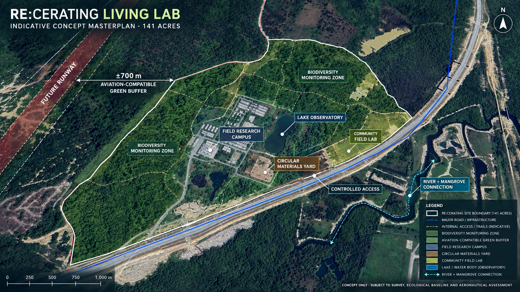
Concept only. Boundaries, distances and programme are indicative and remain subject to survey, ecological baseline, planning approval, aeronautical assessment and wildlife-hazard assessment.
The proposed living lab sits southeast of the future runway end, with an approximately 700-metre green interval. Its role is to prove that aviation planning and ecological intelligence can inform one another from the beginning.
Indicative spatial relationship. Final distances and safeguards remain subject to cadastral, aeronautical and wildlife-hazard assessment.
Structures the challenges, pilots, partners and pathways from evidence to adoption.
 Place & development lead
Connects the site, infrastructure, planning and PAC-wide deployment environment.
Research partnerSupports applied science, validation, talent and knowledge transfer.
Development partnerSupports place activation, delivery coordination and community-facing development.
RE:CERATING / A PAC LIVING LABORATORY